Effects of historical land-use change on species richness and community composition in fragmented and newly created habitats
Historical land-use change may have considerable influence on current ecosystem composition, structure and function. Past local land use can have persistent legacy effects on communities, for example, through alterations of site conditions, soil seed banks or persisting species. At landscape scale, land-use change may drastically alter the spatial configuration of habitats, such as patch size and overall amount and connectivity of the respective habitat type. Habitat configuration is known to affect assembly and diversity of communities. Thus, in cases where habitat configuration changed substantially due to land-use change, the historical habitat configuration may have a significant influence on current communities.
- To map historical land use up to 1 km radius around the 150 grassland EP at four dates: 1870, 1930, 1960, and 2010.
- To calculate various landscape metrics for grasslands and other land-cover types based on the historical land-use maps.
- To model effects of historical land use and grassland configuration on species richness and trait composition of plant and arthropod communities of the grassland EP.
- Historical grassland configuration has got a stronger effect on species richness of plants and arthropods than the current configuration in cases where grassland amount or connectivity have changed strongly.
- Historical land use and grassland configuration explain a significant amount of variation in current trait composition of plant and arthropod communities.
- Species’ traits related to dispersal and persistence interact with the general effects of (historical) grassland area and connectivity on community composition.
1.) Historical land-use and landscape analysis
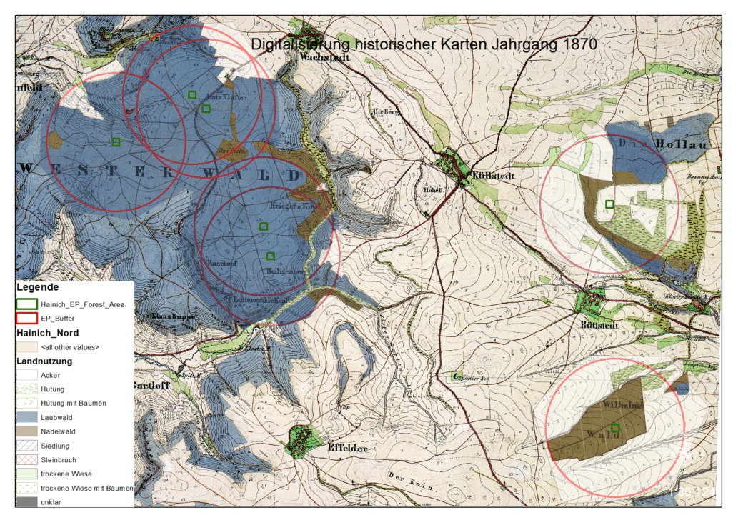
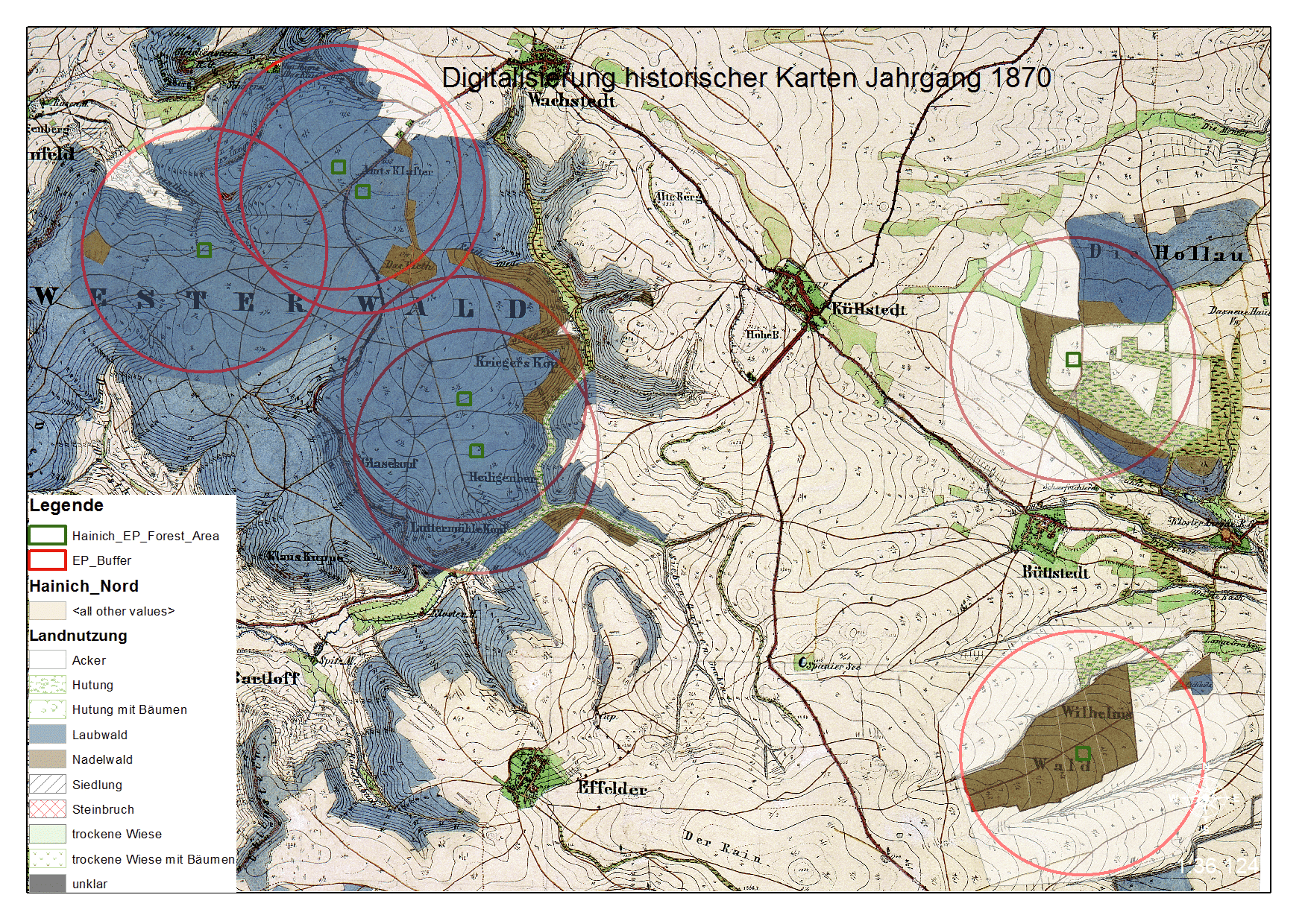
Historical land use will be mapped in buffer radii of 100 m, 250 m, 500 m and 1 km around EP based on digital historical maps in a Geographic Information System (GIS). We will analyse land-use trajectories at local and landscape scale. Further, various landscape metrics (patch area, shape index, nearest-neighbour distance, proximity index, area proportion and number of patches within land-cover types) will be calculated for the central grassland patch (containing the EP) as well as for the whole buffer radii (means within land-cover classes). In this way, we will quantify historical grassland configuration and landscape structure in the Schorheide-Chorin and Schwäbische Alb exploratories. This has already been completed for Hainich-Dün in a preliminary study.
2.) Effects of historical land use and grassland configuration on species richness
Here, we will test the hypotheses that historical habitat configuration affects current species richness and that it is more important than the current configuration if there was a marked change of grassland patch size and/ or total grassland area (increase or decrease). Further, we will specifically analyse cases of recent creation of grassland parcels and expansion of total grassland area in the landscape (e.g., in Hainich-Dün), on one side, and of fragmentation of grasslands on the other. Regarding new grasslands, we will test if grassland area and connectivity at the time of habitat creation explains current species richness. In fragmented grasslands, we will test for extinction debts by comparing species-area relationships of stable and fragmented grassland patches.
3.) Effects of historical land use and grassland configuration on trait composition of communities
In this work package, we will model historical effects on multivariate trait composition, proportion of certain species groups (e.g., habitat specialists) and on community (weighted) means of traits. We will use multivariate analysis to assess the importance of historical land use and grassland configuration for current trait composition of plant and arthropod communities. Then, we will analyse if proportions of specialist species, dispersal-limited species and persistent species depend on historical grassland area and connectivity using Generalized Linear Mixed models (GLMM). Finally, we will model historical effects on community (weighted) means of traits related to dispersal and persistence hypothesising that isolation increases dispersal traits and fragmentation increases persistence traits.
4.) Interactions of species’ traits with effects of historical land use and grassland configuration
We will use a new modelling approach based on GLMM to quantify how much certain traits modify the relationships between species occurrence and historical land use and grassland configuration. We will use RLQ ordination to select traits that are most strongly related to historical land use and habitat configuration. Then, we will test interactions between effects of historical settings and species’ traits using ‘random intercept and random slope models’ GLMM (cf. Jamil et al. 2013). We hypothesise that traits related to dispersal interact with the general effects of habitat area, connectivity and age on species occurrence in new habitats. In fragmented grasslands, we speculate that traits related to population persistence and regeneration will modify the general effect of fragment area, historical habitat area and current connectivity on species occurrence.
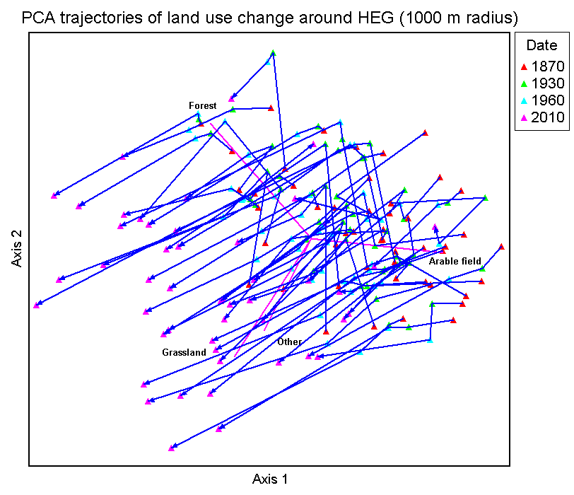
Land use trajectories Hainich: "Trajectories of land use shares on the landscape level in the Hainich"
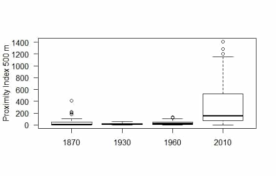
Development of grassland proximities in Hainich: "Development of grassland connectivity in Hainich (in 1-km radii around EP)"
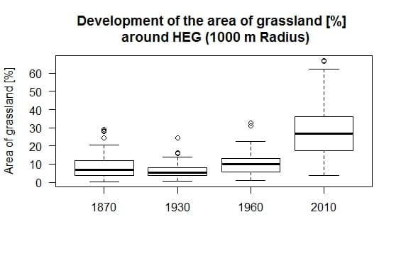
Development of grassland in the Hainich: "Development of grassland in the Hainich (in 1-km radii around EP)"
Public Datasets
Dissemination of historical land-use data
GIS layers of historical land use and the landscape metrics derived from them will be made available to all participants of the Biodiversity Exploratories through BExIS to support further studies on effects of historical land-use change.
References
Jamil T, Ozinga WA, Kleyer M, ter Braak CJF (2013) Selecting traits that explain species-environment relationships: a generalized linear mixed model approach. Journal of Vegetation Science 24: 988–1000.
Scientific assistants